About Me

My photo
Hello! My name is Keith Gault and I've been tramping the hills of the UK and further afield for over 40 years now. This blog records some recent hill days undertaken either on my own, with friends, or with clients under my guided hillwalking Company: Hillways (www.hillways.co.uk). I hope you enjoy my diary; please feel free to comment on any of the walks. I will respond to any direct questions.

Friday 18 October 2013

Skye, Kintail & Killin 2013


The Skye Ridge

What will probably prove to be my last major trip of the year saw Matt & I ranging far and wide as we attempted to tackle some of the Cuillin Ridge on Skye, the Five Sisters of Kintail and some Killin hills, all within the space of an October week.

Sgurr a’ Mhadaidh, Sgurr a’ Ghreadaidh and Sgurr na Banachdich


Sgurr a’ Ghreadaidh

First-off, we headed for Skye where we were received with (mostly) clear blue skies, light winds and plenty of dry rock on which to get Matt intimately acquainted with the Skye Ridge.

We started with my favourite part of the ridge: the central section encompassing  Sgurr a’ Mhadaidh, Sgurr a’ Ghreadaidh and Sgurr na Banachdich.  The usual start from the Glen Brittle youth hostel was unusually quiet and there were few distractions to slow our progress along the familiar path up into Coire a’ Ghreadaidh.
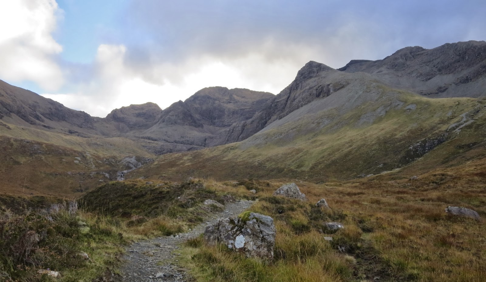

Coire a’ Ghreadaidh

The scree leading up to the notch of An Dorus (the door) appeared to be more stable than usual and we made good time to just below the skyline where we peeled off left to climb the short distance to our first summit of the day: Sgurr a’ Mhadaidh (918m; peak of the fox).


Sgurr a’ Mhadaidh

From this airy viewpoint (well they all are around here!), we picked our way back to the scree-filled gully and climbed up to An Dorus itself.  A self-absorbed fellow climber had rather unhelpfully chosen to have his lunch right in the notch itself.  A few pleasant words (liberally laced with some unpleasant thoughts) were required to get him - and his nice new camouflaged rucksack - out of the way!  Bless…


An Dorus

Once clear of this temporary impediment, we quickly regained the ridge, traversing around the yawning gash of Eag Dubh (black notch) and slipping deftly past the imposing rock tower of the Wart as if it wasn’t there!  In no time at all we were admiring the wholly inappropriate diminutive cairn that crowns one of Skye’s finest peaks: Sgurr a’ Ghreadaidh (973m; peak of torment).


Matt Gliding Deftly Over Sgurr a’ Ghreadaidh

It was decision time for Matt and he wisely chose not to call it a day, but to continue along the sublime summit ridge of Ghreadaidh to its South Top, a mere 100m away.  It’s an interesting (i.e. narrow, tricky and exposed) 100m though and one that lives long in the memory.  In these wonderfully dry and near windless conditions, it offered little resistance and we were soon descending on the other side to a surprisingly grassy bealach where lunch was taken.


Bla Bheinn and Loch Coruisk

Suitably refreshed, we then traversed around the left-side of the Teeth (3 rock pinnacles that straddle the ridge hereabouts) and climbed up and over the sharp rock pyramid of Sgurr Thormaid (927m; Norman’s Peak).  A steep, but straightforward descent led to a narrow bealach before the final climb up a short scree slope and on to Munro No 3: Sgurr na Banachdich (965m; peak of smallpox).


Sgurr na Banachdich & Sgurr a’ Ghreadaidh

Late afternoon sun saw us descending into Coir’ an Eich, down pesky scree slopes, until easy grass slopes welcomed us back and we regained the outward path back to the youth hostel.  A quality mountain day if ever there was one.

Sgurr Mhic Choinnich


Sgurr Mhic Choinnich

Just the one hill today, but what a wee gem it is.  It’s not for the faint-hearted though!  Matt was game so we started from the Glen Brittle Memorial Hut and took the excellent path up past the Eas Mor (big waterfall) and Loch an Fhir-bhallaich to the junction with the main Coire Lagan path at the ‘Matterhorn Rock’. 


Eas Mor

The corrie was sunless – and correspondingly cold at this time of an October morning - so we moved quickly up into the upper corrie, past the eponymous lochan and skirted around the sweeping scree slopes before gaining the distant skyline.

 
The View North From Sgurr Mhic Choinnich

The next 45mins took us gingerly along the airy and exposed ridge high above Coire Lagan on the one side and Loch Coruisk on the other until we reached the small pile of stones that marks the summit: Sgurr Mhic Choinnich (948m; Mackenzie’s Peak).


Looking Along the Summit Ridge

The return is no more straightforward so it was another 45mins back to the foot of An Stac where we descended back down into Coire Lagan and returned the way we had come.  There are a number of tricky steps on the Choinnich ridge so do take care and think twice before tackling it in the wet.  Navigating along it is not as easy as you would think either.

Five Sisters of Kintail


The Five Sisters From Shiel Bridge

Following the thrills of the Black Cuillin, we transferred across to the mainland and spent the next couple of nights in Kintail.  Here we planned to play catch-up on some of Matt’s unfinished Munros.  And so we did.


The Saddle From Glen Shiel

Fearing deteriorating weather, we were pleasantly surprised with what came our way for a traverse of the Five Sisters.  We had the hills to ourselves and took just over an hour to gain the ridgeline at the Bealach an Lapain from the floor of Glen Shiel.


Looking East Along the Ridge

A cool breeze was all we had to contend with in otherwise dry and clear conditions which continued, rather helpfully, all day!  Consequently, the peaks came reasonably quickly and uneventfully as we traversed over them one-by-one to the loud accompaniment of roaring stags in the glens below.  Sgurr nan Spainteach (990m; peak of the Spaniard) was as interesting and enjoyable as ever and we were soon negotiating the little rock step that leads past the landslip and up on to the summit slopes on Sgurr na Ciste Duibhe (1027m; peak of the black chest).


Looking West Towards Sgurr na Ciste Duibhe

From here onwards, we had the great vista westwards along Loch Duich and across the sea to Skye for company.  The stags were still roaring as we fairly painlessly negotiated the shapely cones of Sgurr na Carnach (1002m; rocky peak) and the Sisters’ crowning glory: Sgurr Fhuaran (1067m; peak of the wolf).  As ever (lucky me!), the views from the latter were fabulous in every direction and both near and far.  It’s always a struggle to leave the summit behind and head home.


Sgurr Fhuaran

Still without a soul in sight, we descended from Sgurr Fhuaran and continued along the Five Sisters ridge traversing past Sgurr nan Saighead and Beinn Bhuidhe before leaving the ridge.  We dropped down into Coire na Criche and followed the excellent path alongside the Allt a’ Chruinn and down to the roadside where a 2nd car should always be waiting!

Ciste Dubh


Ciste Dubh From the South

This delightful wee hill has yet to give me a view despite repeated attempts.  It offers a short (4hrs) hill walk, half of which is along a deteriorating track up the boggy glen of An Caorann Beag.  The track starts 50m E of the Cluanie Inn and is good at first.  


Curious Onlooker

One red deer was in no rush to run away and gave us quite a stare as we passed.  The track peters out about 2Km up the glen and that’s a good opportunity to cross over the Allt a’ Chaorainn Bhig and intercept the equally boggy path that leads up to peaty Bealach a’ Choinich at 600m.


Bealach a’ Choinich

The approach walk over, the real climbing now begins with a short, but steep, 150m grassy slope that leads on to much better ground.  A good path traverses alongside  one top and over another.  It then drops slightly before climbing steeply, but quickly, to the summit cairn of Ciste Dubhe (979m; black chest).


Ciste Dubh From the West

No view!  But then you knew that.  I did too…  Just an about-turn and back to the Cluanie Inn - once again to the accompaniment of rutting stags all around!  It was still a good half-day and the summit ridge is always entertaining, whatever the weather.

A Wet Night in Killin

Twenty minutes out from Killin, our intended destination for the end of the week, everything changed.  A phone call announced the failure of the hot water supply at our lodge and Jon decided (wisely) that his recent bout of flu was not conducive to hillwalking so he wouldn’t be joining us for the weekend.  Even in mid-October, finding short-notice  accommodation in the Highlands can be a problem.  We did, however, secure a room in the Killin Hotel for one night which brought us valuable thinking (as well as eating and drinking) time!

Given deteriorating weather (it couldn’t last for ever) and the absence of the others, I suggested we drive over to Atholl and take in Beinn a’ Ghlo before calling it a week and heading home.  And thus it came to pass...

Beinn a’ Ghlo


Beinn a’ Ghlo (On Another Day)!

The great weather we had enjoyed earlier in the week departed with a vengeance and Friday saw us battling over the 3 big summits of Beinn a’ Ghlo in wild winds and almost continuous rain.

As usual, we took advantage of the high start from Loch Moraig above Glen Fender and headed up the Shinagag track. We entered cloud at about 700m and the ferocious winds really took hold on the summit of Carn Liath (975m; grey hill).  Thereafter, we battled our way over this fine mountain massif, taking in the Munros of Braigh Coire Chruinn-bhalgain (1070m; height of the corrie of round blisters) and Carn nan Gabhar (1121m; hill of the goats) before turning for home.

No views, just wind and rain and a little unplanned diversion in thick mist...  We were soon back on track though and splish-sploshing our way down from the Bealach an Fhiodha below Airgiod Bheinn.  We picked up the peaty path that threads across the SE slopes of Carn Liath and eventually intercepts the Shinagag track.  This we followed on the dirtiest of late afternoons as we scuttled home for some long-anticipated chilli-ginger salmon and a glass of Deuchars!  Beinn a’ Ghlo has certainly proved to be a bit of a handful this year.

     
Rum From Skye 

  
Check out my plans for this coming winter at: http://www.hillways.co.uk/winter-hillwalking.htm


Friday 11 October 2013

Autumn Colours in the Cairngorms


Loch an Eilein

A short break in Aviemore yielded the usual crop of enjoyable forest walks, a meeting with Gavin & Katie at Aviemore Business Solutions to launch the new Hillways website and a sublime walk around beautiful Loch an Eilein resplendent in full autumn raiment.  Here's the pick of the photos......


Check out my plans for the coming winter at: http://www.hillways.co.uk/winter-hillwalking/ 

Saturday 5 October 2013

The Pyrenees 2013


Ordesa Canyon

This year’s trip to the Pyrenees turned out to be just as enjoyable and interesting as my previous visits with unexpected weather leading to some rapid re-planning en route!  Still, it was a great week and once again, the stunning scenery did its bit to ensure smiles all round.  Dave and Sue had been planning this visit for a couple of years now so they were delighted to have finally made it here!


Cirque de Gavarnie

Following a most agreeable evening meal and morning stroll around Toulouse, the hire car brought us to Gavarnie in under 2½hrs.  Due to the seasonal closure of the Sarradets Hut, we opted for a circular walk along the Gavarnie Valley for Day 1.  This gave us the opportunity to explore at close quarters, the imposing cliff amphitheatre of the Cirque de Gavarnie and Europe’s highest waterfall, La Grande Cascade.  An hour’s walk up the mule track from the village got us to the Hôtellerie du Cirque and into the upper reaches of this great semi-circle of rock wall.  Here, we were able to spend a good hour getting up close and personal to the vertiginous cliffs of the Cirque and the tumbling waters of the Cascade.  This is a place to linger.


Cirque de Gavarnie & La Grande Cascade

Returning to the Hôtellerie, we took the signposted path that leads behind it and climbs the E side of the Gavarnie Valley to the Plateau de Pailla.  This entertaining path leads through the woods and beneath overhanging cliffs as it climbs steadily to the grassy alp of the plateau.  Another advantage of choosing this route for Day 1 was that it gave us excellent views across the valley to the first part of tomorrow’s trek.  From the plateau, it’s an easy descent back down to Gavarnie on a path that gently zig-zags down through the pines.


Gavarnie Valley

Our trek proper started on Day 2 with a 400m climb from Gavarnie up on to the beautiful Plateau de Bellevue (1720m).  Today we shared this great vantage point with countless sheep and cattle whose clanging bells echoed around the place like a clarion call to prayer.  We left the cacophony behind to climb up into the equally beautiful grassy folds of the Vallée des Pouey d’Aspé with the bells being replaced by the shrieking alarm calls of marmots.

      
Vallée des Pouey d’Aspé

This valley climb led us to the French/Spanish border at the windswept col of the Port de Boucharo (2270m).  Here we bade farewell to France, as well as the forlorn hope of a warm and sunny picnic spot, and descended immediately into the scenic Lapazosa valley.  This leads gently at first, but later more steeply, down into the Valle de Bujaruelo at San Nicolás where a perfect stone bridge crosses the Rio Ara.  From here, a 40-min stroll down a vehicle track brought us to the excellent hostel that was to be our first night’s accommodation.


The Bridge at San Nicolás in the Valle de Bujaruelo

Day 2 of the trek saw us continuing down the track for an hour alongside the turbulent Ara until we stood at the gateway of today’s main objective: the stunning Ordesa Canyon.  Here, we picked up the GR11 long-distance footpath and followed it eastwards through the pines and alongside the Rio Arazas beneath increasingly imposing limestone walls.  A fleeting distant view of the Spanish village of Torla seemed to emphasise we were heading into remote country.  


Torla

An hour’s walk brought us to the road-end and café at the Pradera de Ordesa where we bade farewell to ‘civilisation’ for a couple of days (or so we thought) with a sneaky coffee and comfort break!


 Ordesa Canyon

We spent the next 4hrs walking up the floor of the canyon, climbing steadily through the trees as the Arazas tumbled over a series of photogenic cataracts - at times alongside us, and at others, far below in deep gorges.  Altogether, it was a wonderful way to spend an afternoon, the canyon rim slowly appearing to draw evermore closer as our track continued to climb. 


The Upper Canyon 

Eventually, the trees gave way to an open grassy plain and the head of the canyon lay before us.  We still had over 400m of climbing remaining, but this came all at once as a clear, if rough, path led us up through the encircling cliffs and out of the canyon.  The cliffs gave way to grassy slopes and after one final rise, our destination lay before us: the Goriz Hut (2165m).


The End of the Ordesa Canyon

A major re-build of this strategic and popular refuge is still on hold although the shell of the new extension is complete.  A new ablution block, together with most welcome porcelain facilities, has been added though so the old place is not quite as austere as it used to be to stay!


Goriz Hut

Day 3’s plan had been to climb Mt Perdido (3355m), the 3rd highest mountain in the Pyrenees.  However, the sound of heavy rain lashing against the hut’s windows early the following morning did not bode well.  The rain continued well into the morning and once reports of thunder were added to the mix, we knew we’d lost our peak.  My current success rate for Perdido stands at 33.3%.  Mmmmh….

Content to sit out the day at the Goriz and return to Gavarnie on Day 4, as planned, the plot was further upset when the hut guardian came in and announced that heavy thunderstorms were forecast for the following day!  This had now become a no-brainer and it was obvious we would now have to pack up and depart for Gavarnie post-haste.   This we did, together with Xavi and Louis who had regaled us over supper the previous evening with their optimism, nay expectation, of a soon-to-be independent Catalonia!

 
 Izard - Pyrenean Chamois

Our progress was good at first as we headed westwards along the Faja Luenga and over 2 saddles, the Cuello de Millaris (2454m) and Cuello del Descargador (2495m).  We even got close to a friendly izard, the Pyrenean chamois.  However, by the time we reached the 2nd col, the cloud was down on the deck and things were looking decidedly bleak.  The general deterioration in conditions was not helped by the increasingly rocky moonscape that the terrain assumes in these parts.

Rather skilfully I thought, I interrupted our steady progress for 15mins of position-reorientation practice on non-descript ground in thick mist.  I’m sure no-one noticed….  Eventually though, normal service was restored and we located the cunningly disguised entrance to the broad gulley that leads over tumbledown rock-piles, the odd snowfield and steep scree slopes to the Brèche de Roland (2807m).


Brèche de Roland - on the day! 

This massive cleft has created a toothless gap in the thin wall of rock that hereabouts forms the Pyrenean watershed and French/Spanish border.  It’s an impressive enough place on a fine day, but today we hardly saw it – just a brief glimpse through the clouds a mile away.  Today’s passage was more to do with relief, braving a fierce wind and navigation rather than enjoying the view!  It was more like passing ships in a sea fog than stepping through a magic gateway!  A perennial snowfield lies on the N side of the Brèche and although it is generally soft at this time of year, we briefly donned crampons for the short 5min transit.  We had brought them for Mt Perdido!


Brèche de Roland - and on a better day! 

Suddenly though, things improved markedly.  The clouds lifted, the snow disappeared and the path became clear down to the Sarradets Hut just below us.  Beyond, we were treated to sunlit views of the Gavarnie Valley and the distant foothills of the French Pyrenees.


Pic des Sarradets & the Sarradets Hut

One final sting in the tail – a thought-provoking, but ultimately successful crossing of a rain-swelled glacial outflow stream that barred the way down.  After this, it was all plain sailing as we traversed down to the Port de Boucharo and picked up the remnants of the access road to Xavi’s very welcome waiting campervan at the Col de Tentes (2208m).  We were celebrating in the hotel bar 30mins later!


Port de Boucharo

As a postscript, we did indeed get thunderstorms the following day – very dark, ferocious and powerful ones that brought vicious hail storms and hours of heavy rain.  The thought of being caught out in such conditions, or of trying to get back from Goriz as we had originally planned for that day, was a sobering one indeed!

It was a great trek though and thanks to Dave, Sue, Xavi and Louis for great company and ready flexibility when our plans – and the weather – changed!      


Checkout my future plans at: http://www.hillways.co.uk/summer/scotland.htm