 View From the Ben!
The last week has been spent in the sometimes wild, often wintry, but always interesting mountains of Lochaber. This area of the West Highlands, based around the rather grim, if useful town of Fort William, is home to 4 of the 9 highest mountains in the UK, including the highest: Ben Nevis. It also hosts one of the most picturesque glens in the country: Glen Nevis, a major ski complex, many, many Munros and the stunning defile of Glen Coe. The height of the mountains and the advantage of mountain uplift from the Nevis Range gondola and chairlifts make this an excellent venue for winter skills and is an annual entry on the Hillways calendar. On this trip, Dave was returning for a refresher whilst Sue was trying her hand for the first time in the noble art of winter mountaineering!
 Descending Ben Nevis
Whilst I wouldn’t normally start with the biggest day first, promising weather coupled with an unpromising forecast encouraged us to climb Ben Nevis on Day 1. We were not disappointed. A dry day with a high cloudbase and a generally kind wind enabled us to ascend the Tourist Route fairly easily, pausing to don crampons just above the half-way point, and continue to a summit wrapped in mist and deep in snow. There was no view from the top, but the clouds parted early in the descent to give us great views of the upper part of the mountain and a glimpse of the precipitous north face with its 600m/2000’ cliffs. The whole day took 7hrs, a creditable time given the conditions, and it gave us an ideal introduction to the week’s activities.
 High Point of the Week!
Day 2 was dreicher than dreich with cloud, rain and snow filling the view out of the window to such an extent that a day in the classroom met will all-round approval! It proved to be time well-spent though; the passing horrors outside and frequent cups of exotic infusions (Sue) and tea (Dave) bearing witness to informed, entertaining and illuminating discourses from yours truly on everything from how to survive an avalanche to the origin of the Ordnance Survey! The relative merits of fish pie compared to steak casserole may also have crept in at some stage....!
Day 3 saw us ascending the Nevis Range gondola (enclosed) and chairlift (distinctly unenclosed) to over 900m up the northern flank of Aonach Mòr.
 Tight Rope!
Shrouded in mist, we spent the next 5hrs inspecting the snow pack, peering over massive cornices, and striding off (as much as you can in soft snow) on compass bearings determined by Dave and Sue’s (very) recently acquired navigation skills! Much to their credit, and in near white-out conditions, they located the diminutive snow-covered pile of stones that does for the summit cairn of the UK’s 8th highest mountain: Aonach Mòr (big ridge; 1221m). We continued south for a further 1Km until the intimidating snow-girt cliffs of Aonach Beag loomed out of the mist. We roped up for the tricky steep ascent through ice-caked boulders and on to the UK’s 7th highest mountain: Aonach Beag (small ridge; 1234m). This fine mountain lacks any marker at all in winter other than a point on a snowy cone that you judge to be higher than the rest! I probably choose a different point each year!
 Approaching Aonach Beag
The limited time available until the last gondola down forced a bit of a route march upon us for the return. However, we still found time to peer over the cornices above Coire an Lochan and enjoy stunning views over the Great Glen before removing crampons, stowing ice axes and descending serenely to the valley floor.
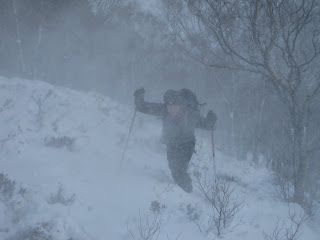
Day 4 started bright and sunny and promised clear conditions for a traverse of the westernmost Mamores. However, danger signs of troubled times ahead soon became evident as we looked up to see clouds flashing over the skyline and storms of spindrift swirling over the ridges.
 Sue Mans Up!
Sure enough, as we climbed above the tree-line up the steep, awkward and snow-covered flank of Mullach nan Coirean’s north ridge, we began to be bombarded by gusty winds and eye-stinging spindrift! Progress became wearingly-slow and a decision to retire gracefully was as sensible as it was inevitable. Interestingly, a pair of climbers on an adjacent ridge whom we had been watching battling against the spindrift had clearly come to the same conclusion. Reassuringly, the Scottish Avalanche Information Service (SAIS) forecaster for Lochaber that day also commented in his daily blog http://saislochaber.blogspot.com/ on the number of parties returning early from Ben Nevis due to the difficult conditions.
 Fresh Snow in Glen Nevis
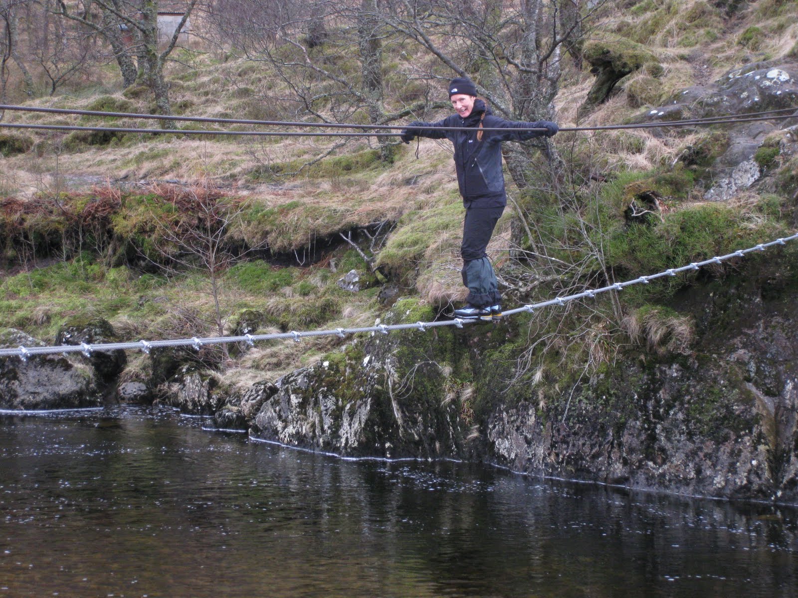
Day 5 was spent at lower altitudes, walking up Glen Nevis to visit the ‘rites of passage’ 3-wire bridge and spending the afternoon practising micro-navigation skills above Fort William. Sue distinguished herself by deftly negotiating the bridge with great aplomb – no sign whatsoever of clenched fists (or anything else, for that matter)!
 That Bridge!
We squelched over to get up close and personal to the always impressive Steall waterfall before returning back over the bridge. The micronav went very well during the afternoon with every insignificant contour line wiggle successfully located in the otherwise featureless bog!
 Man on a Mission!
Day 6 saw bright sunshine, blue skies and cold, clear air. We took the Nevis Range gondola up to the top station on the northern flank of Aonach Mòr and practised various set pieces covering examination of the snow pack, snow belays and ice axe arrests. The latter provided welcome entertainment to the passing skiers and snowboarders against a backdrop of snow white peaks stretching away to the far north west and distant Kintail, Torridon and Skye.
 Winter Skills
All in all, we enjoyed a full week of winter skills in an excellent location well suited to the winter mountaineer!

Check out my future plans for this winter on:
http://www.hillways.co.uk/winter/winter.htm


 This weekend saw a quick return to Fort William to introduce Philip from Holland to the delights of a Scottish winter mountain ascent. He decided to begin at the top and elected to make the mighty Ben his first conquest of a Scottish peak – and in winter! My Dutch was no match for Philip’s English (fortunately) and we only lost ourselves in translation once. Philip seemed unusually unimpressed when I told him that sea eagles could now be seen in Scotland. He thought I was talking about seagulls!
  Sunshine in Glen Nevis
 Approaching the Snowline
 Spring is in the Air (Perhaps)!


 Subscribe To This Feed